4th Grade Science - 4-ESS2-2 - Analyze Maps Of Earth's Features
6 Questions
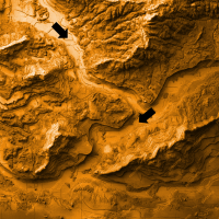
Look at the topographic map below.
The table below shows data collected by a group of scientists mapping a new area. They recorded the elevation and landform type at each stop.
The map below shows earthquake activity for the continent of South America.
What can people learn from analyzing this map? Select two choices.
Determine which statements are true and which are false based on the information found in the map below.
A student is trying to make a map of a nearby hill. Answer the questions below based on this map.
We help forward-thinking Californian districts achieve significant CAASPP score improvements in Science, Language Arts, and Math. Our NGSS-aligned questions ask students to analyze, model, and reason through real-world science challenges.
Learn more